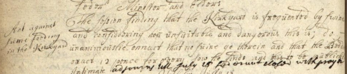
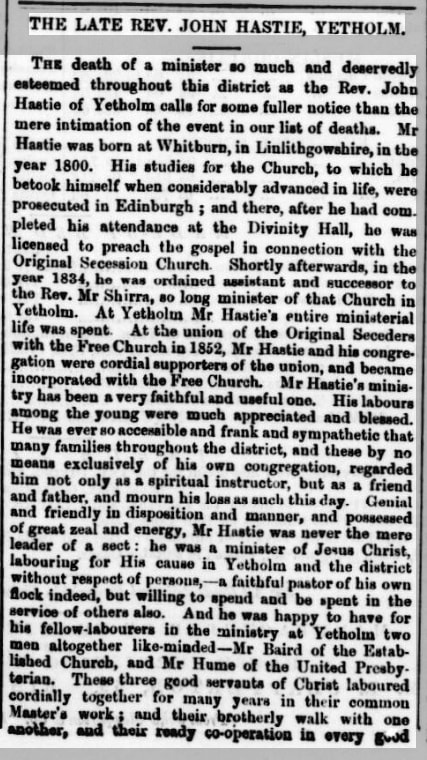
 On June 13th 1703 the Yetholm kirk session met and decided on the above 'Act against swine feeding in the kirkyard': 'The session finding that the Kirkyard is frequented by swine and considering how unsuitable and dangerous this is; do unanimouslie onnact that no swine go therein and that the Beddel exact 12 pence for every sow he finds and this to be publickly Intimate'. The kirk session no longer has any control over the upkeep of the kirkyard - it is now the responsibility of the Scottish Borders Council, who periodically inspect the area, apply a 'hand-pressure test' to each stone and then tip over any deemed a threat to the health and safety of the public. These efforts aren't universally appreciated, though they also cut the grass and keep things relatively neat and tidy. The council's health-and-safety inspections have most impact on the larger and grander gravestones, which are constructed from several pieces of stone and are liable to come apart over time. As already noticed in a previous blog, the gravestone of Andrew Richardson Blythe, a significant benefactor of the church and community, suffered this fate - although it has now been splendidly resurrected - see HERE. Other figures from Yetholm's history, who were once prominent members of the community, have also had their monuments tipped over. This has happened to the stones of several church ministers. The photograph below shows the memorial stone of the Rev. John Hastie, minister of the Free Church on Dow Brae, who died in 1863. His monument stood for over 150 years, but has recently been taken down. The photograph on the left was taken in 2018, the one on the right a few weeks ago. 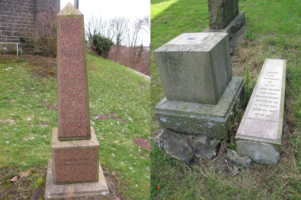 Reverend Hastie's death took place in 1863 and was reported on in the Kelso Chronicle (10th July 1863), at length and in a style long since abandonned by local newspapers:
It is interesting that, despite ecclesiastical dispute and division, the ministers of the three presbyterian churches which were (very) active in Yetholm at that time, would join, together with their congregations, for 'Union Prayer Meetings' - 'a beautiful example of brotherly love'. The Kelso Chronicle obituary then goes on to remind readers that the early 1860s had seen successive deaths among the clergy of Yetholm. The Rev. Baird of the Established church had died in November 1861 and the Rev. Hume of the United Presbyterian church (which met in what is now the Wauchope Hall) died in December 1861. Then, to the obvious shock of the community, the Rev. Ebenezer Whyte, the young replacement minister to the long-serving Rev. Hume, died within days of the Rev. Hastie. His obituary in the Kelso Chronicle immediately follows that of the Rev. Hastie, shown above. The Rev. Walter Hume had served for 44 years as minister of the UP congregation. Latterly, in frail health, he was assisted by the Rev. Whyte, to took charge after the Rev. Hume died. Whyte only served for two years as minister. The two men were commemorated by a joint memorial stone on the wall of their church - shown in the photograph below. This stone was removed when the building became the Wauchope Hall and placed in the garden of the house that had been the UP manse. It now belongs to the History Society and is simply propped against the wall of the old Mission Hall/Heritage Centre. We need to find a more permanent way of displaying the stone, although it is too heavy to put on the wall (and there is no space!): 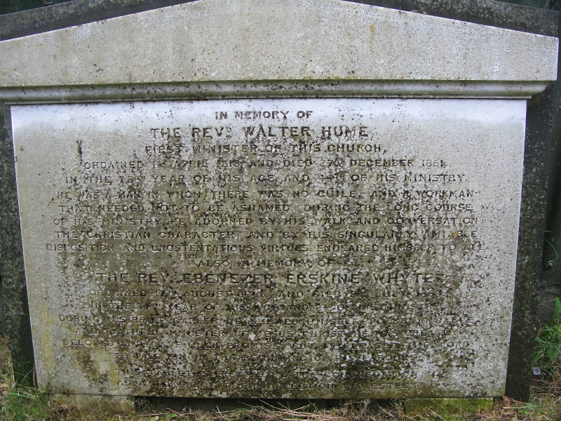 However, the grave memorial that is perhaps most shockingly derelict is that of the Rev. John Baird, the minister of the Established church. Baird, more than anyone else, had a profound influence on the built environment of Yetholm. Under his energetic influence a splendid new bridge replaced the rickety wooden footbridge that joined Kirk- to Town Yetholm, a new schoolhouse was built (now the Youth Hostel) and a state-of-the-art church built on the site of the picturesque, but dilapidated, old kirk. John Baird came from a relatively privileged clerical background, but his life was not without its tragedies. He married Margaret Oliver (b.1813), daughter of Robert Oliver of Blakelaw, in 1833. They had two daughters, Margaret (1834) and Sarah (1836), but his wife died in September 1837 aged just 24. The 1841 census shows him living the manse, along with his unmarried sister Elizabeth, who presumably acted as a surrogate mother. Then, tragically, the two young girls died a few years later – Margaret in 1845 aged nine and Sarah in 1846 aged ten. In 1849 he married for the second time. Elizabeth (Bessie) Hughes was from Ireland. They had four children – James Oliver (1852), Anna Margaret (1853), Nathaniel Hughes (1855), Sarah Mary (1860). John himself died on 29th November 1861 of ‘Hepatic disease’, when his youngest daughter was less than a year old. His health had been ‘precarious’ for a while and he had visited Ireland in the Summer before he died, but this trip was ‘not attended by any improvement’. He was 62 years old. As he lay dying he could hear the sound of the coronation festivities for the gipsy Queen Esther in the distance. The current council maintainance regime ensures the grass in the kirkyard is cut short - and, as already noted, that monuments deemed unstable are tipped over. However the grass cutting efforts are relatively rough-and-ready. Many monuments are left covered in ivy or have tree saplings starting to grow from their base. In some ways the situation of family enclosures is the most neglected of all. The council motor-mower is unable to get in and they are left to turn into a jungle. This is the case of the enclosure for the Baird family (and of that of his predecessor the Rev. Blackie, which is adjacent). It is now very badly overgrown: 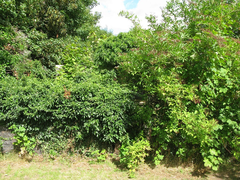 After hacking one's way through the undergrowth and then removing the ivy, the neat slate stones that commemorate Baird and his family are eventually revealed. There are three stones altogether - shown below is the one which the Rev. Baird erected for his first wife, her sister and their two young daughters. His name added at the end: 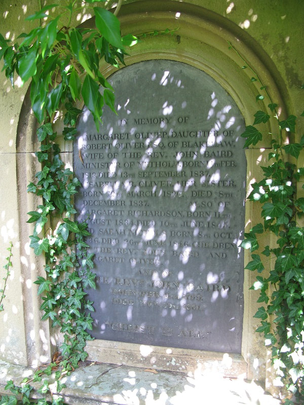 Baird is the earliest minister for whom we have a photograph. In those days carte-de-visites showing prominent kirk ministers were offered for sale to the general public - times have changed, only film stars and tiktok personalities get that kind of adulation today! Mrs Wilson, 'Bookseller and Stationer' of Kelso, advertised several such clerical portraits in the Kelso Chronicle of 1864, including one of of the Rev. Ebeneezer Whyte, although no known copy of this survives. The portrait of the Rev. John Baird shown below is probably a copy of the one which she also advertises for sale: 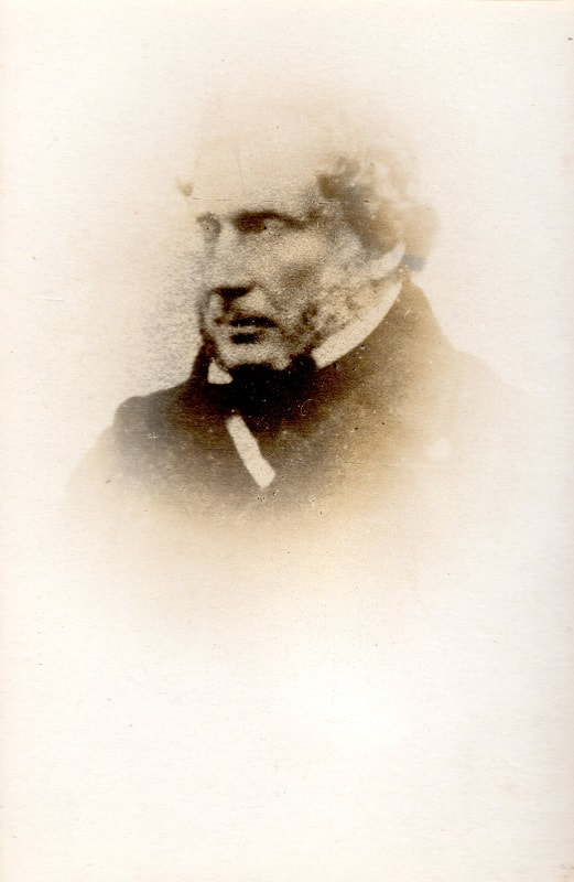 "Christ is All"
0 Comments
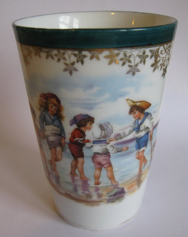
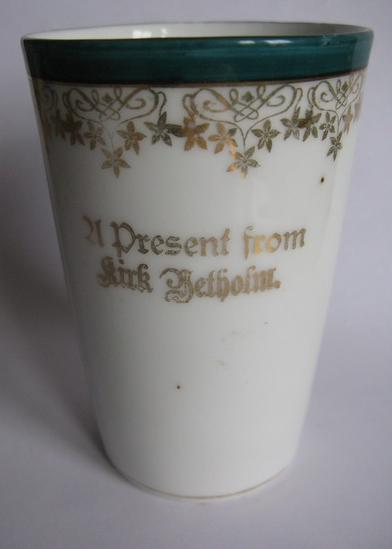
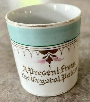
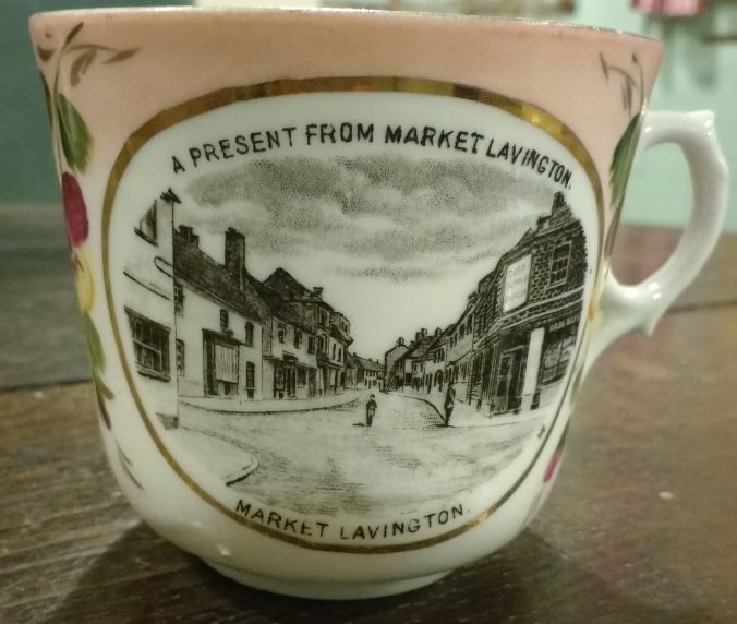
Yetholm History Society is delighted to have recently received from Jenni Smith, of Huntsman’s Cottage, the colourful mug shown above. Our Heritage Centre has limited space, so we don’t collect or display many objects – our collecting policy is that anything we accept must have a connection with Yetholm or the Bowmont Valley. At first sight the mug can’t have any link with Yetholm. We are, after all, over twenty miles from the sea. However if the mug is turned around the following text appears; ‘A Present from Kirk Yetholm’. It will make a nice companion piece to the Kirk Yetholm cup-and-saucer which were donated to the society by Betty Mallen (see below - currently on display in the Heritage Centre). All of these items probably date to the early years of the twentieth-century, when Yetholm was growing as a local tourist destination. Wealthy people had holidayed in the area since the early nineteenth-century – shooting was popular with gentelmen. With the coming of the railway to Mindrum, opened in the 1880s, humbler folk from the Central Belt and Tyneside came to lodge for a week in the summer with locals. Many visitors went to the Gipsy Royal Palace in Kirk Yetholm, where they were entertained by conversation with the monarch and a display of coronation regalia. Even after the death of the last king, in 1902, Yetholm remained the ‘Gipsy Capital’ in popular imagination - this association is reflected in the cup-and-saucer, which shows the Gipsy Palace in Kirk Yetholm. 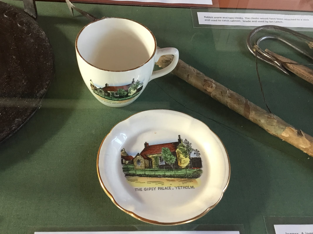 The image on the cup and saucer shows the brick porch, with was added to the palace after the coronation of King Charles in 1898. Click on image to enlarge. Why, then, does the mug given to us by Jenni show an image of the seaside? A scoot round the internet shows several similar cups and mugs for sale. Some have no images on them, just the message – ‘A Present from…’ Others, as with our cup-and-saucer, show an image from the place concerned. Many are from well-known resorts, as with mug from the Crystal Palace (below left), which has similar lettering to ours, but some are from quite small villages, like Yetholm. The image below right is taken from the blog of Market Lavington Museum*. I’m sorry to say that I had never heard of the place or knew where it was – probably the people of Market Lavington are in equal ignorance about Yetholm – but it too seems to have been something of a tourist destination at the time.
Clearly such items could be ordered from manufacturers, who would customize their designs for the vendor who placed the order. Looking closely at the Yetholm mug it is clear that the type used to print ‘Kirk Yetholm’ is slightly different from the type used for ‘A Present from…’ But whether it was the vendor or the manufacturer who, in this case, chose the image is unknown. It must have been confusing for whoever received this present, if they didn’t know the area, to associate Yetholm with a day on the beach! And what did the locals make of it – most children in the village only saw the beach once a year, if they were lucky, when the population departed en masse for the annual Spittal Trip.
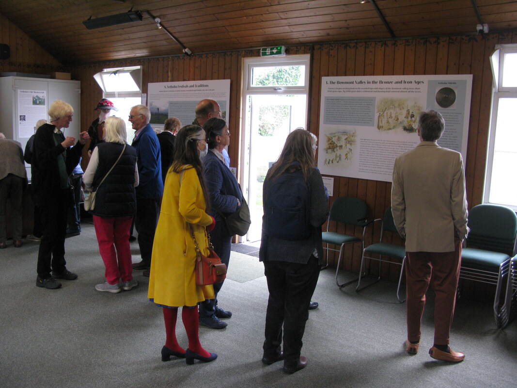
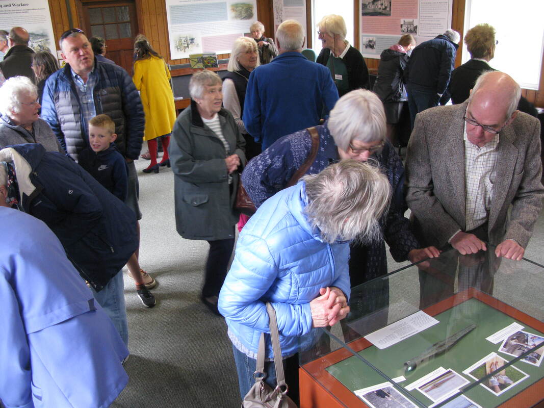
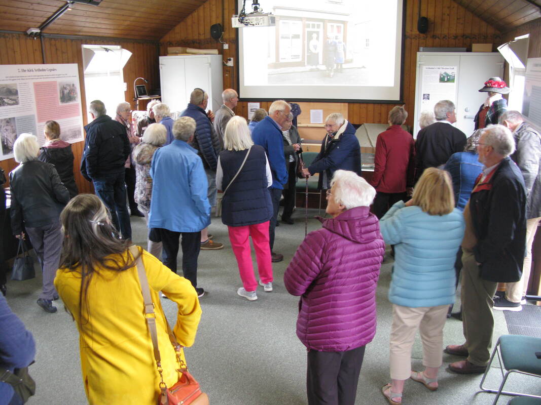
Whatever the case, having now viewed several similar souvenirs from the period online, I think it is fair to saw that this Yetholm example is one of the most charming! *See HERE. Market Lavington is in Wiltshire on the northern edge of the Salisbury Plain. It has to be admitted, as is clear from the image, that Market Lavington is a rather more substantial place than Yetholm. 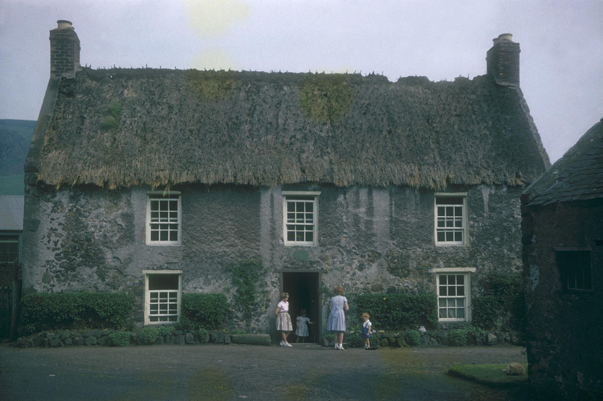 Ivy Cottage, 1958. The survival of many thatched cottages until well into the twentieth century perhaps partially explains why Yetholm has been so well photographed. Several such images are well known, but I recently discovered the one shown above on the website of Falkirk Community Trust. It was taken by John Peat Munn in 1958, who was clearly visiting the area at that date and the old cottage must have caught his eye. Further details about him and the image can be found HERE. We do, in fact, have another photograph of this cottage, which can be found in the RCAHMS volume for Roxburghshire, and which is viewable on the Canmore website - HERE. It is good, however, to have this better quality colour image. The RCAHMS volume describes the cottage, known as 'Ivy Cottage', as 'an oblong house of two storeys, built of harled rubble without dressings. There is an oval stone above the entrance bearing the initials of Peter Lamb and the date 1775. On the ground floor there are two rooms and a central staircase, while the upper floor contains three bedrooms. The overall dimensions are 43 ft by 19 ft 10 in.' There are several records for members of the Lamb family in Town Yetholm in the 18th and 19th centuries, though 'Peter Lamb' remains obscure. Ivy Cottage was sited immediately in front of the Mission Hall, which now houses Yetholm Heritage Centre - the Mission Hall, with its corrugated iron roof, can just be glimpsed on the left of the photo. Sadly, the photograph must have been taken shortly before the cottage's demolition - one of many in the village which were destroyed in the 1960s. Olde worlde charm was no defense against the march of progress! Few now remember the building. Robin Butler recalls it as the home of Jock Allan, a clever, mechanical-minded man, who built himself an electric generator, which was used by villagers to recharge their radio batteries during the Second World War. Doug Turnbull, who sadly recently died, has a short description of the Allan family in his chapter 'Auld Yetholm in the 1930s and 1940s' in Byegone Yethom, published by YHS in 2006: 'In front of it [the Mission Hall] stood the thatched house in which the Allans lived. John Allan was a postman and also a saddler and a very clever engineer. Jock, May and Tommy Allan were good play-mates pre-war. Jock was older than me and a very clever chap with his hands. If Jock had been educated and trained he would have gone places - a good mind wasted!' Who knows, Jock may well have approved of the buildings which replaced his cottage - see below - which may not have the attractiveness of the old thatched cottage, but which have electricity and all other mod-cons. One wonders what became of the date-stone above the door. Perhaps one day it will be discovered under the earth when the current buildings are eventually demolished.  The site of Ivy Cottage today. 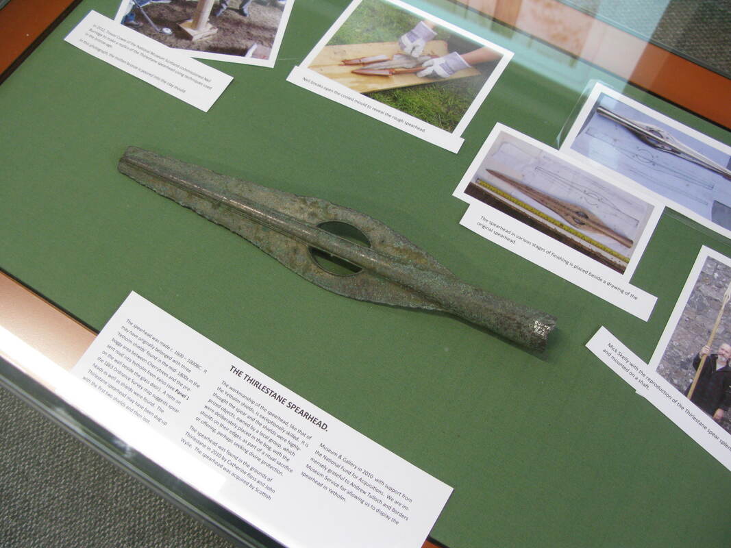 The Thirlstane spearhead. Saturday 21st of June saw the much-anticipated opening of our Heritage Centre. Guests from near and far afield attended the ceremony. They were serenaded by Matt Seattle on border pipes and chatted over tea and cakes in the Youth Hall. Speeches were given by David Hutchinson (History Society chairman) and Jan Rae (wife of Bill Rae, founder of our archive). After the ribbon was cut our visitors could see for themselves the results of all our hard work and were able to get a rare view of the bronze-age Thirlstane spearhead (part of the hoard found in the 19th century, including the famous 'Yetholm Shields'), which was loaned to us for the day by the SBC museum service. A minibus shuttled visitors to the kirk to see the companion display which has been created in the 'Upper Room' there. A selection of photos of the event can be seen below. Since opening the new Heritage Centre has received a steady stream of visitors, who have left many enthusiastic comments. 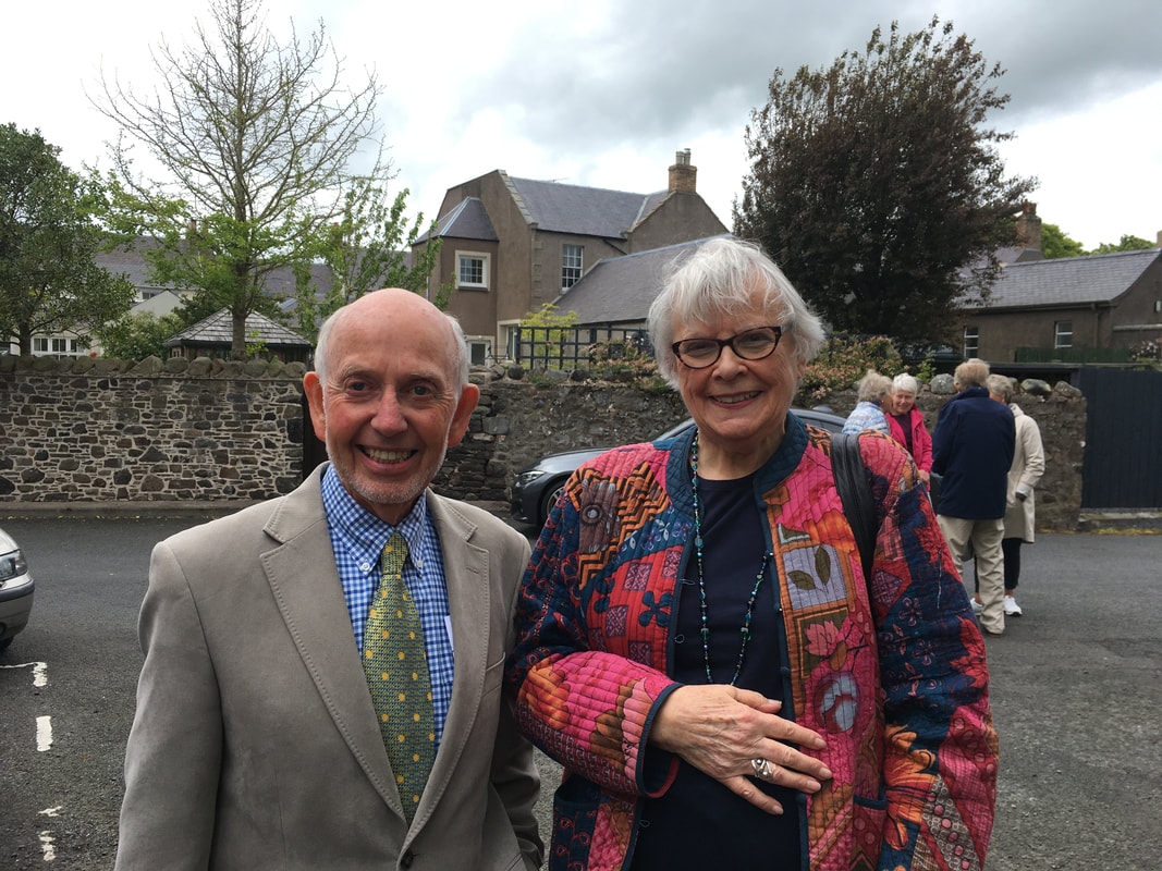 David Hutchinson & Jan Rae.
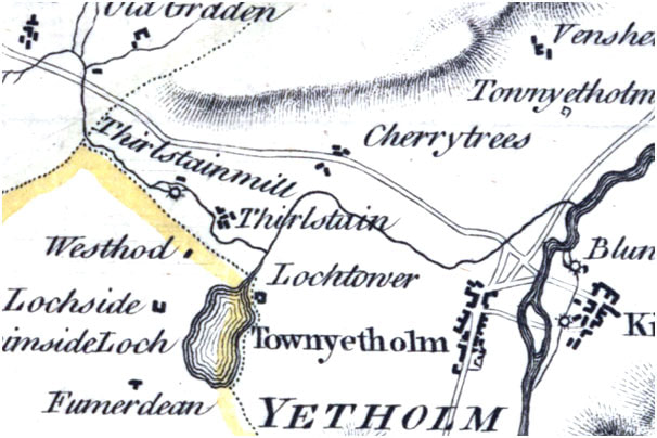
    'Yetholm Show' by Jan Rae.  Just north of Yetholm, on your right as you drive toward Kelso, and halfway along a broad, nameless glen, lies Thirlestane House, now a private dwelling with an extensive garden. This is the remnant of a once much larger estate, now part of Cherrytrees, which included Thirlestane Hill to the north. 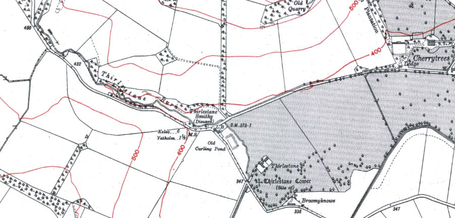 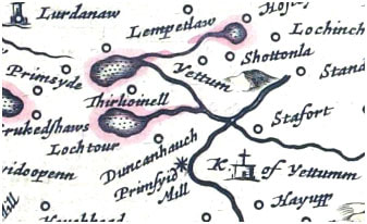 ‘Thirlestown’ is first mentioned in 1542 as part of a punitive raid by the English against settlements just northwest of Yetholm. Subsequently, it appears as ‘Thirlstane’ or ‘Thirlestonne’ in deeds and tax rolls from the seventeenth century*. The name is not uncommon and could have a number of origins – As Middle Scottish ‘Thirlistoun’ it may be a reference to a settlement occupied by peasants in obligation to a lord. As ‘Thirlestane’ it could be taken from the Berwickshire family name, itself derived from the word for a pierced stone (AS ‘thyrel stan’). However, similar names, such as ‘Thurlaston’ in England, suggest that such place names can be derived from the early settlement ‘tuns’ of individuals (e.g. Torlave, Turchile, Thorlak) which have been rationalised to something understandable by later inhabitants of the area. According to legend Thirlestane still had a surviving tower in the seventeenth century. By the nineteenth century, although the tower had gone Thirlestane had an associated smithy (now ‘Catch-A-Penny’), as shown on the first Ordnance Survey map of the area. But Thirlestane also had a mill. Thirlestane Mill may first show up on Blaeu’s 1654 map of the area as ‘Thirlioinell’. The name appears quite corrupt, and in all likelihood should say ‘Thirlis mill’, but the corruption is unsurprising. The information for Blaeu’s map was gathered by Timothy Pont around 1600 and only 50 years later, long after Pont’s death, was a map based on this information published in Amsterdam. Many of the names on Blaeu’s map are slightly distorted (e.g. Scarutch), presumably due to the original handwriting being difficult for the Dutch mapmakers to read. 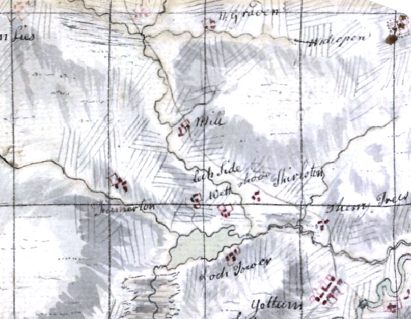 However, even if this interpretation is wrong a mill belonging to Thirlestane certainly appears on a 1661 sale deed. A hundred years later a mill, probably the same, is shown on Roy’s Military map a little way up the Thirlestane Burn just below a side stream and just to the southwest of the old main road to Kelso as it skirts the south side of Thirlestane Hill. By 1770 ‘Thirlstainmill’, apparently a now little further downstream and with a mill lade (the artificial channel for running water to the mill wheel), appears on Stobie’s map of Roxburghshire. The mill is still mentioned as a nominal part of the Thirlestane Estate in the 1800 will of George Walker. However, by the time that Ainslie’s revised copy of Stobie’s map appeared in 1821 the mill was no longer marked.
The mill is absent from all subsequent surveys, although there may be a trace of its existence in the Ordnance Survey 1 to 25 inch scale survey map of 1860. Here, a mill lade is shown just to the north of the new Kelso road west of Thirlestane Smithy. 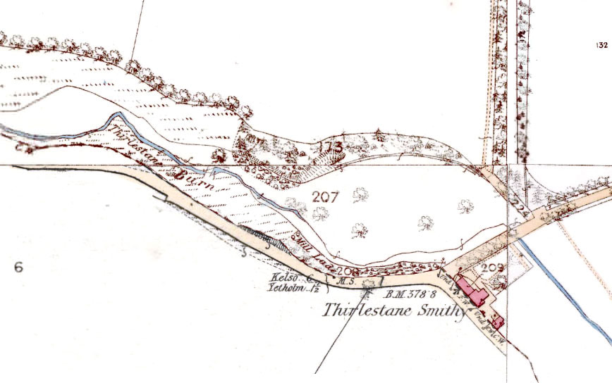 Having visited the site of the ‘mill lade’ there is indeed evidence for an artificial channel, not quite where marked on the map but to the NW and exactly paralleling the road. The channel sits several metres above the present course of the burn. That this channel must have once held water is clear from a series of breaches in it which have eroded gulleys down to the stream. 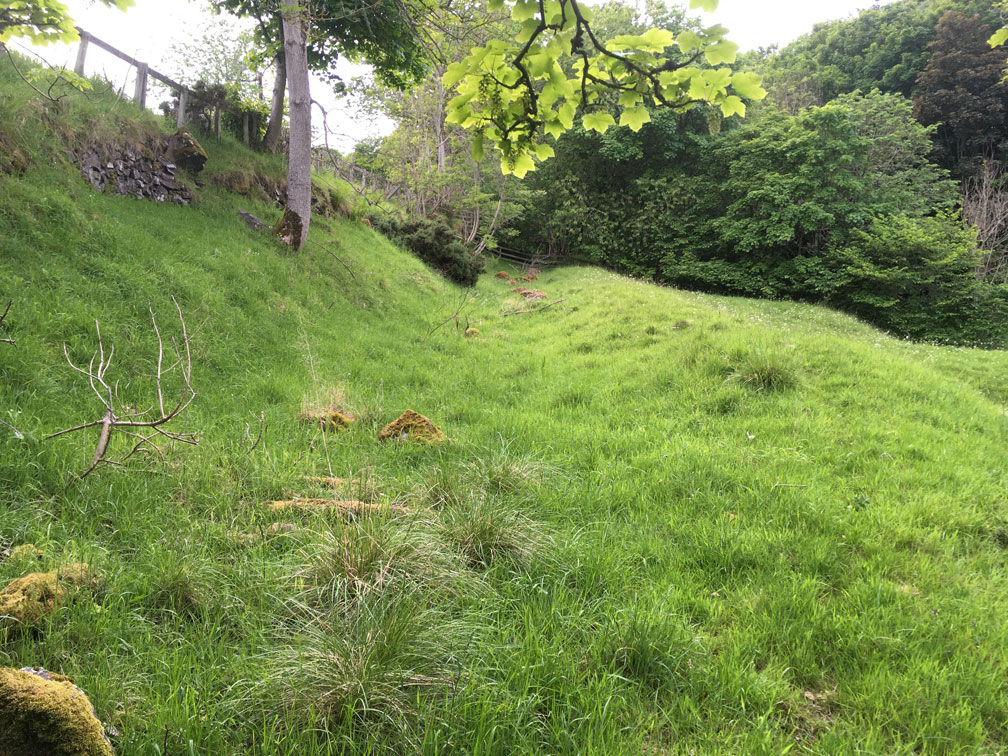 At this point I want to digress and explain why anyone should put a mill on Thirlstane Burn. This tiny stream descends through a small gorge, or ‘cleugh’, cut by the stream in its drop from the open country of Greenlees and Graden farms in the northwest down to the glen in which Thirlestane House, Lochtower and Cherrytrees sit. The stream has a relatively steep gradient within the gorge, meaning that a there is a suitable head of water to run a mill just here. Incidentally, the word cleugh may have given the mill its other name, that of Clock Mill, which survived into the 19th century in the alternative name for Thirlestane Smithy, ‘Clock Mill Smithy’. By the way, in case you’re confused by the position of the road in the maps above, suffice to say that the Old Kelso-Yetholm Road used to run from Graden north of the cleugh and down past Cherrytrees. When the new Kelso-Yetholm Road was built at some time between 1820 and 1840 the road was diverted south of the cleugh, before splitting, one part rejoining the Cherrytrees road, the other continuing in a more straight line to Yetholm. To return ... so where was the mill? As a little experiment, I’ve superimposed both the Roy and Stobie Maps over a 1918 OS map of the area. 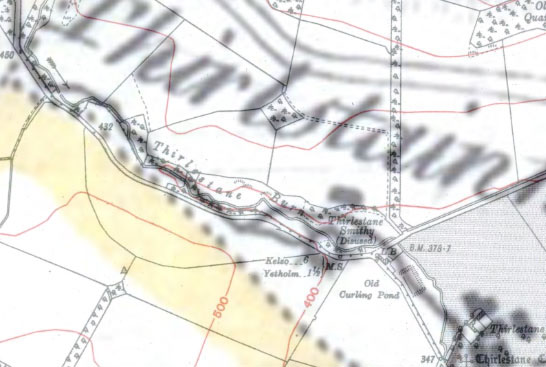 The Stobie map is cartographically quite accurate and allows for a reasonably simple overlay, placing the mill clearly just to the west of Thirlestane Smithy and just north of the burn. This also places the mill lade in about the right position to match the remains of the channel. So it looks like we have a rough idea of where the mill was. 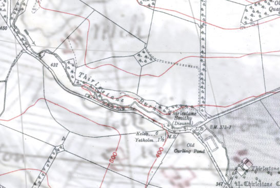 Unfortunately Roy’s map is not so cartographically accurate and needed some distortion to overlay onto the OS map in order that Graden (not shown), Thirlestane and the stream were in the right places. Regardless, it shows the mill considerably higher up Thirlestane Burn. This would be relatively easy to write-off due to the inaccuracy of the map, but the position of an incoming stream just by the mill matches the position of an old stream which is now dry. A few weeks ago I chanced to look at the stream just near the point where Roy’s mill would be. I found this: 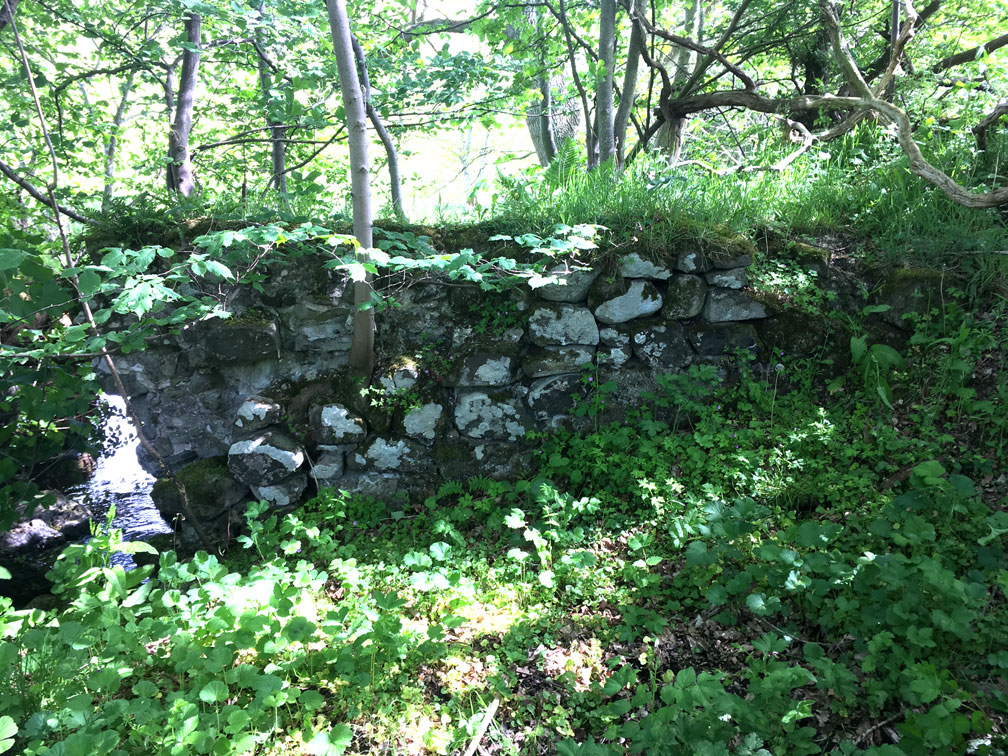 It’s a section of lime-mortared wall about 4 metres long and 1.5 metres high, made up of large, rounded river cobbles. The wall has been slightly truncated at the river’s edge, but it appears that the river has not shifted much, as a small section of mortared wall, approximately at right angles to the first, can be traced on the other side of the stream below a fallen tree. Both walls have been built upon an outcrop of rock in the river such that the water makes a small waterfall here. The ground on the upstream side of the wall is soft and waterlogged.  The style of the wall tells us two things; firstly that the wall is for a building or dam. Normal enclosure dikes for stock were dry-built, i.e. without the use of mortar. Secondly the wall is old. The use of river cobbles seems to have been largely abandoned in the late eighteenth or nineteenth century when enclosure required the opening up of many quarries to supply the new need for more stone.
Given the unusual location of this wall, it looks like the wall might be part of a milldam. Such dams were used to store water in small streams with low flow power to use for occasional milling operations. If it is a milldam then either there were two mills, which is possible if they are not the same age. However, the mill lade and milldam may be part of one mill system. The milldam base sits at an elevation of about 129 metres above sea level. The mill lade channel has an elevation of between 120 and 119 metres, which, given it has probably silted up, means that it could be up to a metre deeper than this. The distance between the two is about 500 metres, giving a channel gradient of 1 in 50, so it’s perfectly possible that the dam supplied the lade and the mill. We have evidence of a milldam and a mill lade, so it might seem surprising that the mill buildings should have disappeared so completely. However, the combined effects of stone robbing to build enclosure walls, road engineering works and the rapid downcutting of the stream in the last two-hundred years have made the location of the mill far less obvious than it might otherwise have been. Wherever Thirlestane mill was, it was probably abandoned at the beginning of the 19th century after the new, improving landowner, Mr Adam Boyd of Cherrytrees, bought Thirlestane from the Walker family. Many such local mills were abandoned in the coming century due to ‘outsourcing’ and competition from coal in a new age of cheaper energy. It makes one wonder if such mills might yet be back. References: The information on Thirlestane’s early history comes from J. Bain’s 1890 edition of the Hamilton Papers Vol 1 p304 (https://archive.org/details/cu31924091786032 ) and from J.H. Stevenson’s edition of the Registrum Magni Sigilli Regum Scottorum (Register of the Great Seal) Vol 11, p54, (https://babel.hathitrust.org/cgi/pt?id=njp.32101073592006&view=1up&seq=1). The Blaeu, Roy, Stobie, Ainslie and Ordnance Survey Maps of Roxburghshire come from the National Library of Scotland map archives (at https://maps.nls.uk). The 1678 Tax Roll information on Yetholm Parish and the Ordnance Survey Name Book information on Thirlestane Tower (Roxburgh Vol 42) can be found at scotlandsplaces.gov.uk The record of Clock Mill Smithy can be found in the 1851 & 1861 Census Returns (ref 811/2/18 & 13 at https://www.scotlandspeople.gov.uk/guides/census-returns. The records of the Walker family (of Thirlestane) are in the Scottish Borders Archive SBA/183 box 2/1 (49). N Pegler 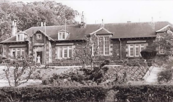 We were recently sent some wonderful photographs by Isobel Pilkington, the daughter of Thomas Brown who was headmaster at Yetholm School from 1952 to 1958. Thomas Brown was a keen gardener and a bee-keeper. One of Mrs Pilkington’s photographs shows the extensive school garden belonging to the schoolhouse and another shows Mr Brown collecting a swarm of bees from a tree on the green in front of Bowmont Terrace. 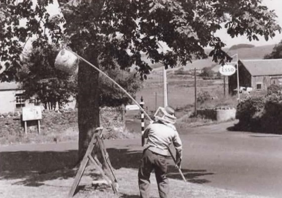 In the 1950s, when Thomas Brown was headmaster, school children were not expected to help either with the garden or with bee-keeping. However, this was not the case in the 1920s and 1930s. The headteachers at Yetholm School in that period, first Mr Alexander Bell and then Mr George Jenkins, were keen to develop a Rural Sciences curriculum for the older children. A report by an HMI (School Inspector) in 1928 praised this aspect of the School’s teaching: 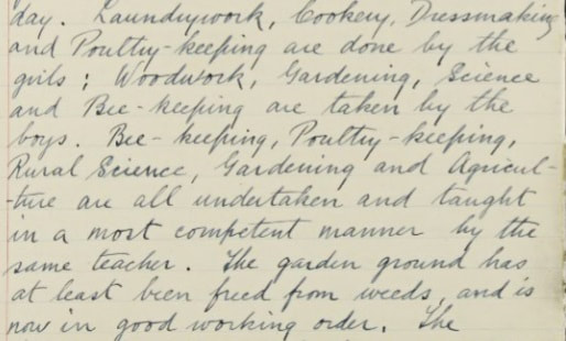 Thus, between the wars, bee-keeping and gardening were a regular part of the curriculum for the boys at least. The same report says that the boys spent the best art of one day on Rural Science, while the girls spent more than a day on their rural skills. However, not everything went smoothly all the time . During a busy period in 1935 collecting bee swarms for the school, the Rural Sciences teacher, Miss Bain, got badly stung: 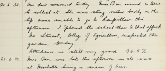 A well known resident of Yetholm, Mrs Elma Goodfellow, recalled keeping hens and bees when she was a pupil at the School before the Second World War. There is a recording and transcript of her interview HERE
Here is the bit about the garden: ‘We kept hens . . and you also kept bees, I remember being told once about this story about the bee-keeping and there were two very special bees being brought all the way from Italy. And Mr Jenkins, who was the headmaster, finally got word that the bees were at Berwick Station. He was allowed to go down there and collect them. One was for Yetholm School and the other was for Denholm, and Miss Finn . . was going to take the one bee up to Denholm. But unfortunately she got into her little car, she sat on it and that poor bee that had survived all the way from Italy, succumbed in Miss Finn’s car at Yetholm.’ 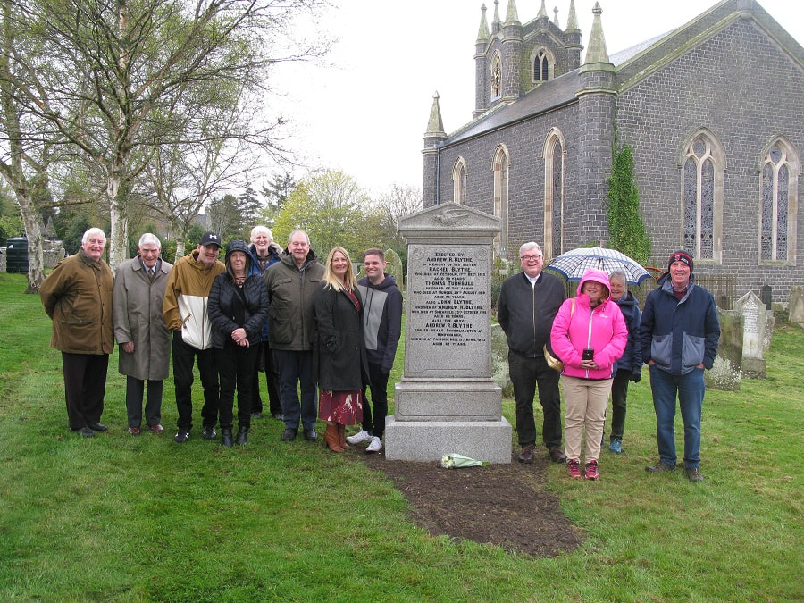 Friends and well-wishers gather round the grave of Andrew Richardson Blythe. On Tuesday 26th April we were pleased to honour one of Yetholm’s notable characters – Andrew Richardson Blythe (1851-1933) – with the restoration and resurrection of his gravestone in the kirk yard. Andrew Blythe, son of a gipsy, came from very impoverished circumstances. At the age of four he had an arm amputated after a shooting accident. Despite the difficult circumstances of his childhood he became a teacher at Windyhaugh School in the Coquet Valley, Northumberland, for almost 50 years. Much loved by the community there and in his home village, he left all his money to Yetholm when he died. His most notable benefactions were the William Wilson stained-glass windows in the kirk, some of the finest 20th century windows in the Borders, as well as the clock chimes that still ring out over the village. Unfortunately his gravestone – perhaps the one indulgence he allowed himself – was recently pushed over. Jayne Gray organized a GoFundMe Campaign to repair the stone, which had broken into several pieces. It raised £560 and the work, which included cleaning the stone, was completed by Thomas Brown and Sons of Melrose. Jayne Grey said: It seemed so wrong that a much-liked man who gave so much to the community should be dishonoured. I am very grateful to all friends and family members who have contributed to this campaign to restore his gravestone. A group of family members and well-wishers gathered on Tuesday to ‘unveil’ the magnificently restored stone. The Rev. Colin Johnstone, minister of Cheviot churches said: It is heart-warming to see people from all over southern Scotland and the north of England gathered here today to pay your respects to Andrew. The stone has been so well restored that hopefully it will stand for at least another two hundred years. 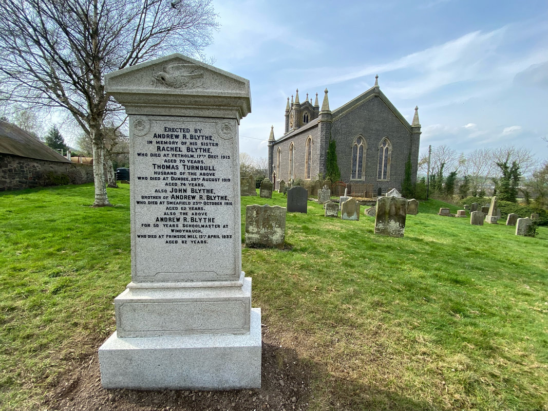 The restored gravestone - photo taken on a sunnier day! 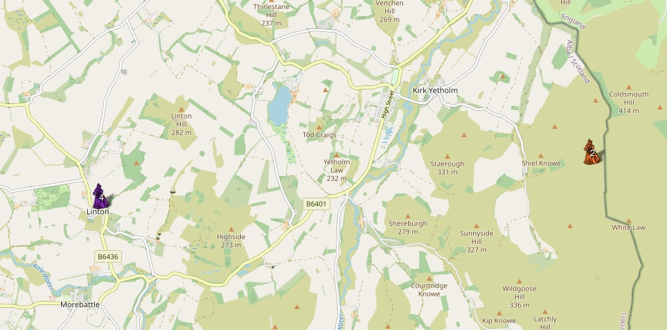 First Minister Nicola Sturgeon has recently issued a ‘posthumous apology to the thousands of people persecuted as witches in Scotland, underlining that the deep misogyny that motivated this “colossal” injustice is something women today still have to live with’. See The Guardian website HERE. One of the pieces of evidence that is used is the Survey of Scottish Witchcraft -‘a comprehensive database of known prosecutions, between the first execution in 1479 and the last in 1727, [during which] at least 2,500 people were killed’. The Survey can be accessed HERE. A portion of the map which was produced to display the Survey’s findings is shown above. As can be seen it indicates that there is evidence of two witches near Yetholm and four at Linton. The two witches said to live near Yetholm are said to be resident at Stob Stanes, which seems rather unlikely, given that the site is so exposed and there is no evidence of habitation up there. In fact, the map is unreliable – and demonstrably wrong as far as some of the named people are concerned. The two women who are said to be from Stob Stanes are Katherine Lawder and someone described as the ‘wife of Wilson’. The notes for the latter acknowledge that the person is ‘probably from somewhere in the Lothians’. Katherine Lawder’s case is discussed in Catherine Roberston’s MSc. thesis Panic and Persecution: Witchhunting in East Lothian, 1628-31, available online HERE. This confirms the fact that Katherine came from near Haddington (as the notes that actually accompany the map acknowledge). ‘Stobstane’, in both these cases, must be the place of that name near Coulston, on the outskirts of Haddington. That this is probable is shown by a transcription of some of the documentation relating to the mysterious ‘wife of Wilson’ which is available online HERE (page 51): 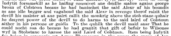 The Stobstane near Haddington is no longer extant, but that such a farmtoun once existed can be seen on Roy’s military map of the 1750s, which shows it slightly to the east of the town, spelled ‘Stabstane’ (and near to ‘Monkcraig’, the ‘Monkrig’ mentioned in the trial documentation): 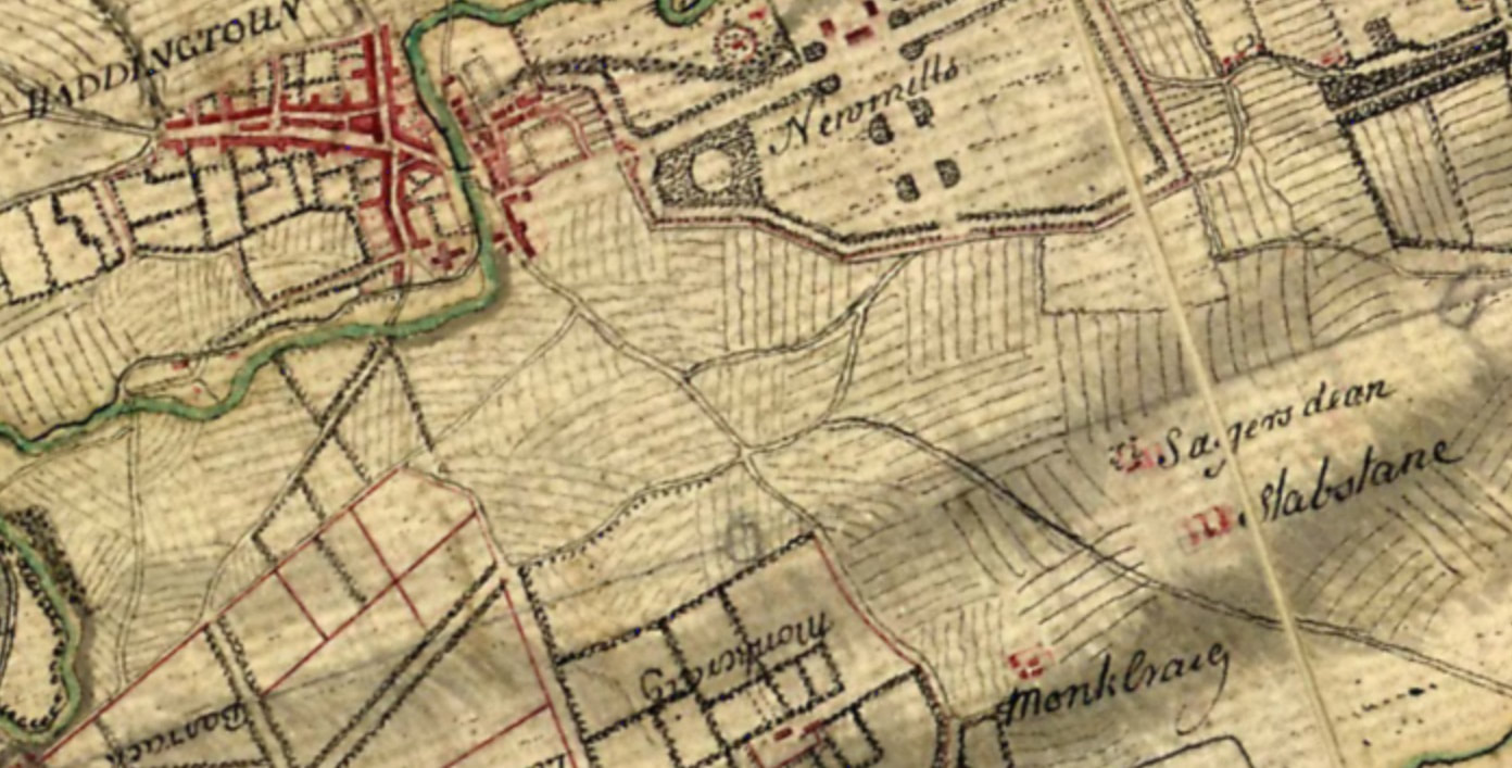 'Stabstane' can be seen on the right of the map. It seems clear, then, that neither Katherine Lauder or ‘Wilson’s Wife’ lived anywhere near the Stob Stanes on Yetholm Common! There is, admittedly, a ‘Witchcleugh Burn’ below Yetholm's Stob Stanes, but the origin of this name is unknown. It first appears in the mid-1850’s Ordnance maps and does not occur in earlier charters. If it is evidence of witches in the Yetholm area then they are nameless. The evidence provided by the Survey of Scottish Witches map for witches at Linton near Yetholm is similarly unreliable. Three of the witches there – Christian Thomesone, James Doddes and Jeane Abbot – are clearly said in the website notes to be from the parish of Linton in the Presbytery of Peebles. The Linton in this case must, then, be the town now known as West Linton, fifty miles or so from Linton in Roxburghshire. There is less information about a fourth witch, Janet Hogg, and the website notes comment ‘This could be West Linton (Peebles) or Linton in Teviotdale (Kelso), but Prestonhaugh (Prestonkirk) is in Dunbar presbytery. I cannot make a definite decision about the parish/presbytery or county.’ The scholarship behind the Survey of Scottish Witchcraft map would seem to be – at least in these cases – somewhat sloppy. Unfortunately the campaign to pardon early-modern individuals accused of casting spells has generated a lot of publicity and some of the claims on which it is based have leaked out into wider circulation. Alasdair Allan, for example, MSP for the Western Isles (but whose family are from Yetholm), refers to the existence of witches at Stob Stanes in his recent book Tweed rins tae the Ocean (2021), an account of his trek along the Border line. That there were witch crazes in the 16th and 17th centuries may be the case, but might it be said that we are in the midst of a witch craze today – only now with the aim of finding and ‘forgiving’ as many witches as possible? The current campaign to pardon people accused of witchcraft in the past seems driven by contemporary obsessions, at the expense of attempting to see the world through the eyes of those who were actually involved at the time. In an earlier YHS blog we looked at several cases where individuals in Yetholm were rebuked by the Session of cursing others in the devil’s name – HERE. As discussed in that blog post, it is important to recognise that such cursing was viewed as a real and very dangerous thing to do; the devil was not a symbol, or metaphor, but a malign force that could wreak havoc in society. It is also possible that some (many?) of the individuals accused of witchcraft in the past were not innocent victims, but truly sought to hurt and kill others. Clearly in some (many?) trials it was the accusers who were malign (or deranged), but in many cases we simply have the accused’s name with no details of the evidence. Did none of them ever cast spells? We might not believe in the efficacy of such things, but people then did. 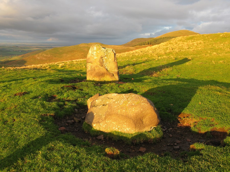 The Stob Stanes 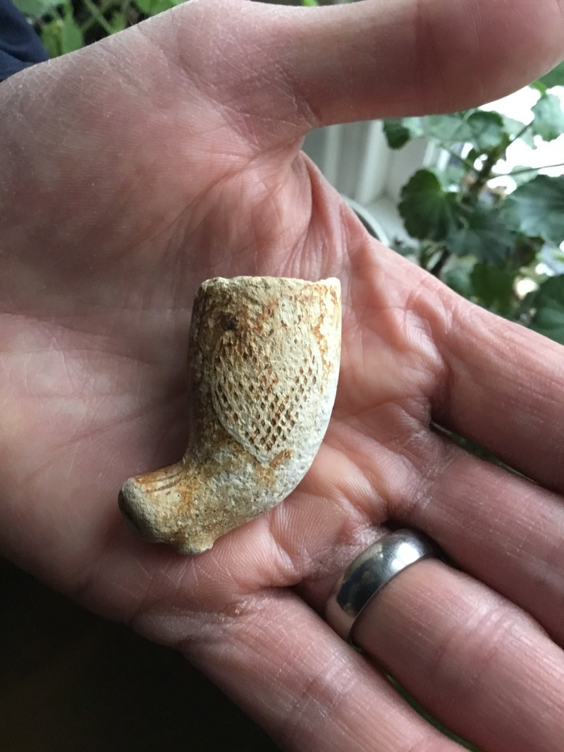 In January we did a blog about various bits and pieces that had been found on the Town Yetholm haugh - HERE. One of the items discussed then was an old pipe bowl. It’s easy to find bits from old clay pipes scattered all around Yetholm – mainly bits of pipe stem, with an occasional bowl fragment. Chris Burton and his daughter, rummaging around in the gravel along the Bowmont Water, have recently found the example shown above. For once this is rather more interesting than the usual plain fragment, being decorated with a heart shape. Similar decorated pipe bowls to be found on the internet make a variety of claims about the symbolism. Sometimes the heart is coupled with an image of hand with a smaller heart held in its palm. Some claim this as a patriotic Irish emblem - the hand-holding-a-heart being the Red Hand of Ulster. Others claim it is a masonic icon, linked to the Oddfellows. The source for such ideas are unclear. Unfortunately the internet generates and duplicates a lot of unchecked guesswork. On the other hand ... the internet also threw up the photograph shown below - from Wikimedia Commons - HERE. The notes that go with it read: English: A white pipe clay tobacco pipe, dating to the mid nineteenth century. The pipe is complete and does not appear to have been used. The stem is stamped with the words 'TENNANT & SON' and 'BERWICK'. The bowl is stamped with the initials 'TW' within an oval depression. There is a raised heart motif on one side of the bowl. The heart motif is decorated with cross hatching. The pipe has a small circular section spur. The bowl has a diameter of 23mm and a height of 42mm. The stem has a maximum diameter of 10mm. The pipe as a whole is 133mm in length. Whatever the symbolism of the heart it seems highly likely, given the location of the find, that Chris's pipe was also made by Tennant and Son of Berwick and would have looked exactly the same when complete. As with the example found on Wikimedia, the pipe bowl found on the haugh was only decorated on one side, displaying a heart and no hand. Who knows what it was meant to symbolise - perhaps simply that the owner loved to smoke and dream? 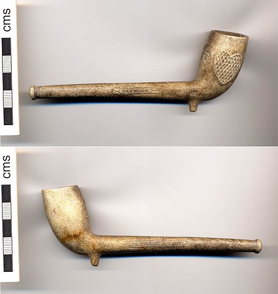 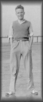 The 1939-45 period is only sparsely recorded in our archives - men were away from home, few tourists visited and sent postcards, there was a general news blackout... It was interesting, therefore, to be contacted recently by Phil Bradshaw in connection with his grandfather Alfred Bradshaw (left), who found himself stationed in the village for several months in the Spring of 1941. Phil writes: Alfred Bradshaw was originally from Stafford, and joined up a few months earlier. He had originally been with a different unit and was moved up from Leeds. When based at Yetholm he was with Army Medical Corps, as part of the 196th Field Ambulance unit. They started to arrive towards the end of 1940 (but the unit was still forming at this time). There would have been around 200 men from this particular RAMC unit there. By April of '41 they had moved to a place near Bury, Lancashire. Alfred's service record, with references to Yetholm, is shown below.  One wonders why Yetholm was chosen for this unit and what kind of training the men received here - and where 200 men could have been accommodated? Phil writes that: 'I'm not sure where they stayed, another member of the unit says that a few of them were first put up at the village hall for a night or two, before going on to proper quarters.' The 'village hall' must have been the Wauchope Hall, but where were these 'proper quarters'? Phil has also sent us a memory of their time in Yetholm by another member of the 196th Field Ambulance Unit, Alan Nixon: We were drafted to the Scottish Border village of Yetholm, and it was a great billet in the winter of 1940-1. The people were very kind to us and we made many friends. We used to go to the village pub for a pint and a Scottish pub-goer there nearly always treated us to a Drambui each as a chaser, my first introduction to it, which has led to a life-long love of the stuff. We had daily marches and drilled around the village during which times we had to suffer snowballing attacks from the local kids. This countinued until the NCO in charge of us got fed up and said "right lads" and we turned around and gave chase with a barrage of our own. Then as a treat we trooped back to the local bakers to sample the freshly-baked bread. It was certainly a happy three or four month period in Scottish Yetholm. We left there in Spring when the Border hills were looking their best, with some sense of regret. These happy memories contrast with the subsequent grim fate of the unit. They were sent to Singapore and were taken prisoner by the Japanese in February 1942. Many of them never returned home, although Alfred was liberated in Thailand in August 1945 and arrived back in Southampton in October of that Year. A prison index card from his time as prisoner of the Japanese is shown below. It is somewhat ironic that one the few records we have relating to Yetholm in the WW2 period is about a German prisoner - a subject for a later blog - who was held here (and worked on local farms), while men from Britain were scattered elsewhere around the world. 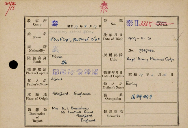 |
Archives
May 2024
|

 RSS Feed
